CONTACT US
Please fill out our
Contact Form
Or email us at:
The Coleraine Historical Society Inc.
PO BOX 53726
Colerain Twp., OH 45253
CHS Monthly Membership Meeting 3rd Wednesday
See Meetings Page for more details
PUBLIC WELCOME Bring a friend!
Get Social.

Connect with us on
Facebook to learn about upcoming projects and volunteer opportunities.

CHS is now part of Butler Rural Electric Cooperative's
Co-op Connections Get $5 off first year's membership
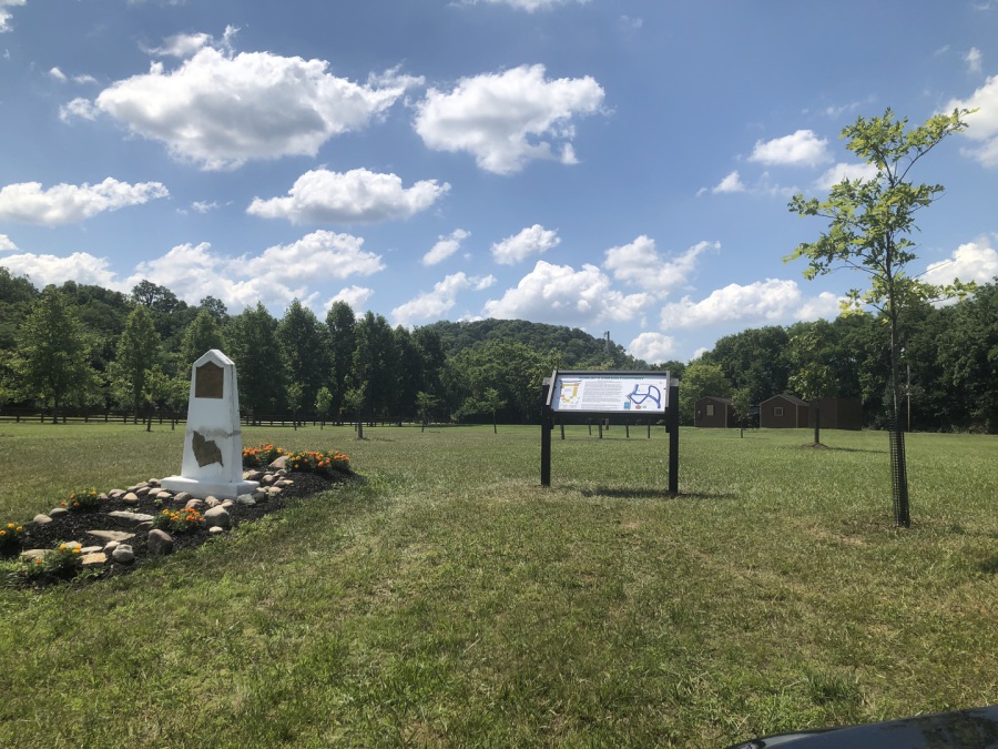
Heritage Park - Dunlap's Station Outline
For article on HISTORY OF DUNLAP'S STATION, scroll to bottom of page
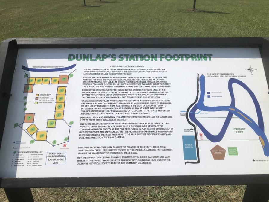
History of Dunlap's Station
It took 3 years but the outlining of Dunlap's Station was finally completed with the July 2023 installation of the sign. Designed by CHS Member, Larry Shad then framed and installed by Mike Riesenberg, the sign identifies the 25 trees, tells the story of Dunlap's Station, and shows how the floods moved the course of the Great Miami River.
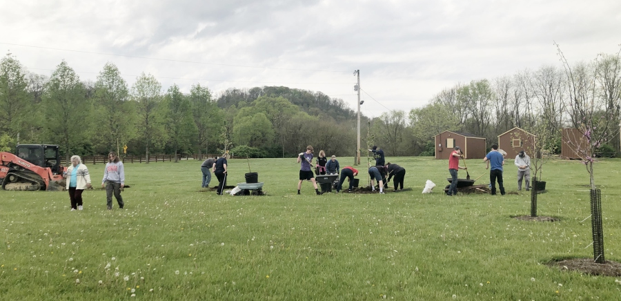
Sat. April 30, 2022
9 New trees
added to
Dunlap's Station Outline
The holes were dug by equipment; but volunteers were needed
to place tree, backfill hole, mulch & fence.
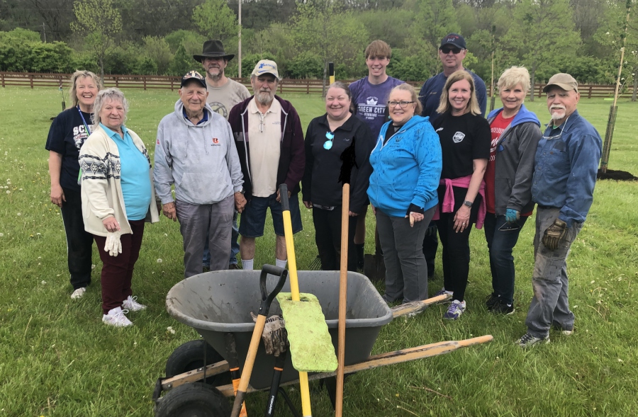
THANKS to Volunteers:
State Representative
Cindy Abrams and her son Nolan
Colerain Twp Fire Chief Allen Walls
Boy Scout Leader Mark Murphy
Boy Scout Patrick Slawnyk
Aron Sullivan
Lori McMullin
Carly Shiplett
CHS Members: Debbie Behrle Debby Scheid Larry Shad Margie Mohr JoAnn & Ron Bertram Chris & Gary Henson
SPECIAL THANKS to Dr. Jim Muth for use of excavation equipment
SPECIAL THANKS to bobcat operator Danny Corcoran
Dunlap Station Outline Project receives Grant
5 Trees were planted in October 2021 to bring the total to 10 trees in the Dunlap Station Outline Project. The completed design has 24 trees.
In late November 2021, CHS received a generous $4500 grant from the
“Priscilla Garrison Haffner Fund” to complete this Project. The 14 remaining trees
will be purchased in Spring 2022 and (hopefully) planted in time for our annual dedication ceremony on May 7, 2022.
Longtime CHS Member, Dee Bardes is administrator of the fund which was created in memory of her Mother Priscillia Haffner.
CHS is very thankful that due to receiving this grant, our project will now be able to be completed far sooner than we had planned.
Thank you, Dee, for your support and generosity towards this project.


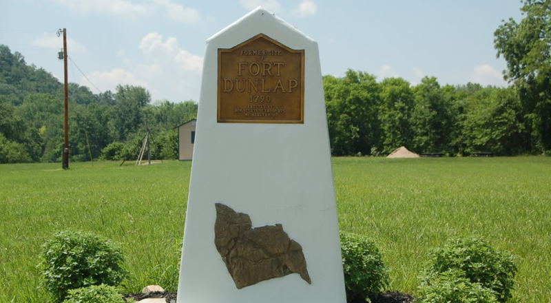
Dunlap's Station, later referred to as Fort Colerain was on the east bank
of the Great Miami River, and was established in early 1790.
A marker placed by Boy Scouts in 1960s mistakenly referred to the area as to "Ft. Dunlap".
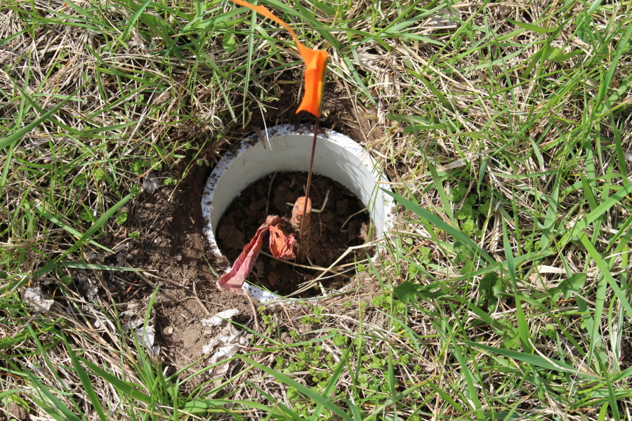
PHASE 1
MARK PROJECT OUTLINE :
To place surveyor 43 iron pins on the outline of Dunlap's Station. Then encase each pin with a PVC collar and fill with concrete.

PHASE 1 Completed April 4, 2020
Thanks to Surveyor LARRY SHAD for marking the pins.
Thanks to GARY HENSON for installing PVC collars and concrete.
PHASE 2
NATIVE TREE PROJECT:
To facilitate and coordinate the outlining of the Dunlap Station “Footprint” native Trees.
This Project to be completed solely through donations.
With help of White Oak Garden Center, a detailed plan for planting 24 Native Trees has been developed. As monies are donated to the project, trees will be planted.
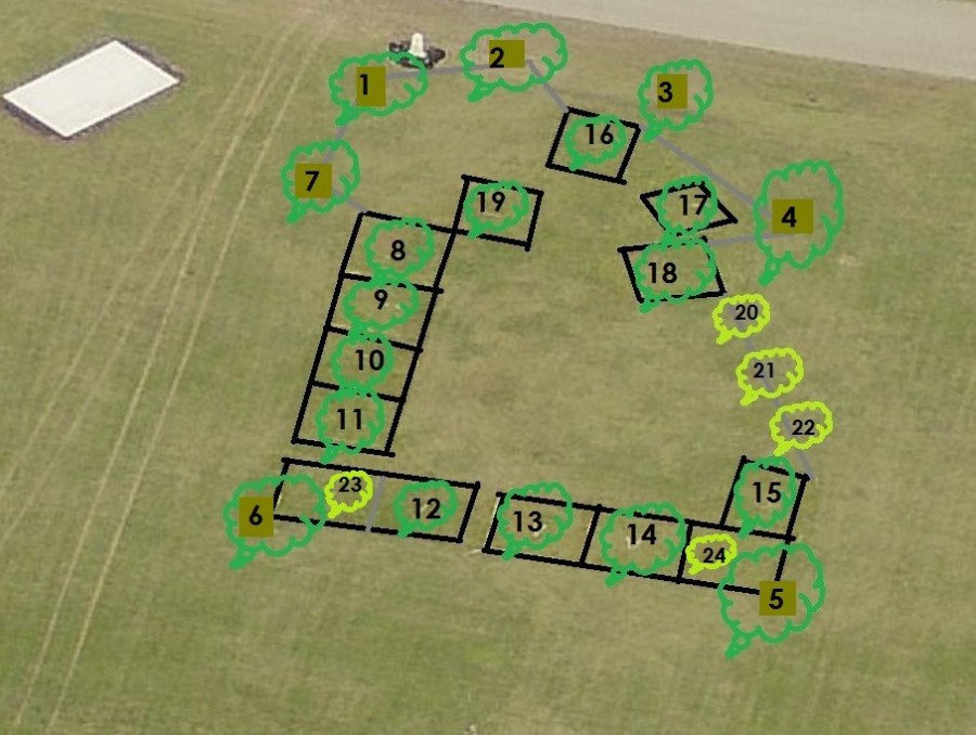
1. White OAK planted 9/2019 12. Service Berry planted 4/2022
2. Tulip POPLAR planted 9/2019 13. Service Berry planted 4/2022
3. Sugar MAPLE planted 9/2020 14. Service Berry planted 4/2022
4. Burr OAK planted 9/2020 15. Service Berry planted 4/2022
5. Tulip POPLAR planted 9/2020 16. Paw-Paw planted 5/2022
6. Sawtooth OAK planted 10/2021 17. Paw-Paw planted 5/2022
7. Shagbark HICKORY planted 5/2022 18. Paw-Paw planted 5/2022
8. Red Bud planted 10/2021 19. Paw-Paw planted 5/2022
9. Red Bud planted 10/2021 20. Red Bud planted 4/2022
10. Red Bud planted 10/2021 21. Red Bud planted 4/2022
11. Red Bud planted 10/2021 22. Red Bud planted 4/2022
23. Service Berry planted 4/2022
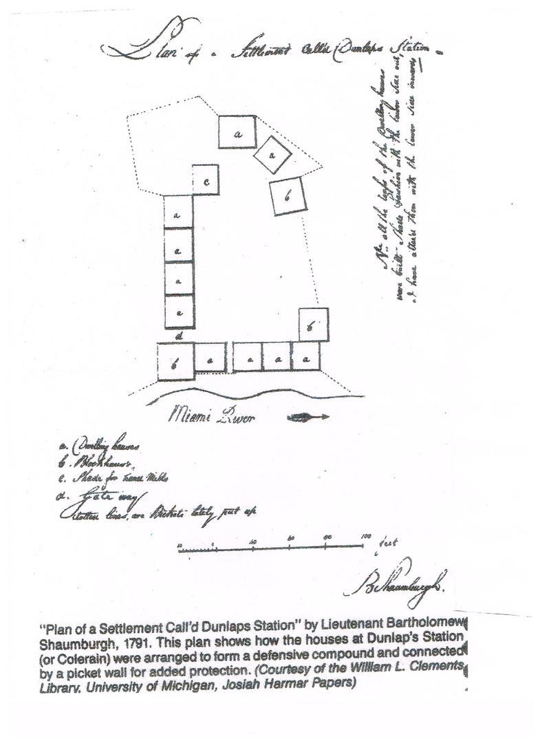
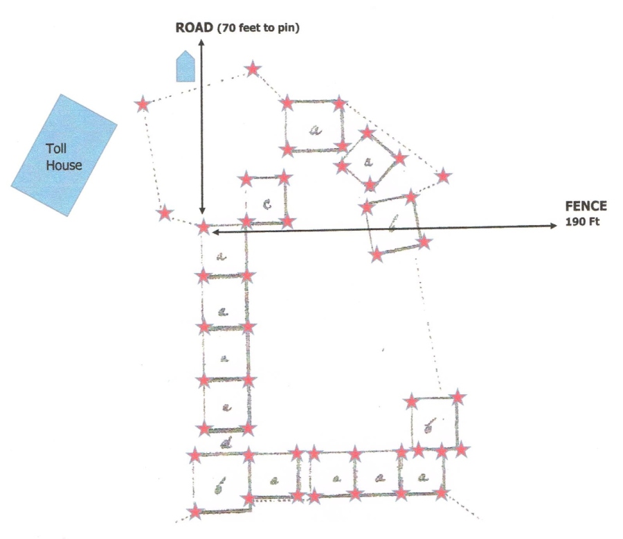
MAP LEGEND:
a. Dwelling Houses
b. Block Houses
c. Shade for hona mills (our best guess is the writer meant "animals"
d. Gateway
Dotted lines are dichete lately put up (our best guess is "dictated later to be put up"
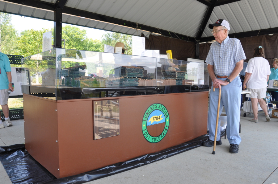
On permanent display in the Rotunda of
the Colerain Township Administration Building,
the scale model of
Dunlap’s Station,
was built by member
Bob Muehlenhard
The Coleraine Historical Society considers the Muehlenhard Model to be the single most important visual piece in our collection that serves to preserve and share history with the Township residents.
HISTORY OF DUNLAP’S STATION –
WHERE COLERAIN TOWNSHIP BEGAN
On August 24, 1749 French explorers buried a lead tablet at where the Great Miami River joined the Ohio River; thus proclaiming the land for France. For the next 100 years, that lead tablet would be used for surveying purposes. The French later sold the land to the United States as part of the Louisiana Purchase.
October 1785, The United States sends General George R. Clark to the area and he establishes Ft. Finney near the mouth of the Great Miami River.
January 1786, the Shawnee Tribes give up control of the lands east of the Great Miami River by signing the Fort Finney Treaty with General Clark.
In 1787, The United States Congress created the Northwest Territory which included Ohio, Indiana, Illinois, Michigan, Wisconsin and a section of Minnesota. The land was described as being “West of the Allegheny River, North of the Ohio River, and East of The Mississippi River”.
THE SYMMES PURCHASE Excerpts from an Feb 1997 Article in the Coleraine Pageant
Benjamin Stites was visiting in what is now Maysville Kentucky when Indians stole some of his horses. As he pursued them through the wilderness in Ohio, he was so impressed with the fertility and beauty of the country that he told his friend, Judge John Cleves Symmes, of its possibilities.
In 1792, Judge John Cleves Symmes formed a syndicate, the Miami Company, and convinced the Congress to allow him to purchase a large tract of land between the Great Miami and Little Miami Rivers known as the Symmes Purchase or Miami Purchase. Symmes with the first group of settlers founded the town of North Bend. From there he enlisted the services of a friend, John Dunlap. Dunlap was a Surveyor and Symmes needed his land plotted and boundaries marked so he could sell off parcels of the territory to arriving settlers.
After surveying and plotting the land, in 1790, John Dunlap ventured up the Great Miami River to a spot along the East side about seventeen miles Northwest of Ft. Washington (on Ohio River). Dunlap named the area Coleraine, because of the rolling hills and winding river that reminded him of his homeland – Coleraine, Ireland. The northern border of Coleraine was actually five sections (about 3 miles) more north than it is today. It extended into what is now Butler County.
In Coleraine, along a large bend in the Great Miami River, Dunlap and a small band of settlers started clearing an acre of land. Then they built small cabins with roofs slopping to the rear to keep rain draining away. The cabins were built in close proximity to each other. They hoped this arrangement would improve safety and protection from the Indians who roamed the area in violation of the Fort Finney Treaty with General Clark.
This band of settlers also built an eight foot high stockade wall. This wall was not very sturdy, as settlers split the logs used for posts so they could cover more length of stockade wall using fewer logs and cutting down fewer trees. They also built the stockade wall between the cabins using the back wall of each cabin as part of the stockade wall. Using the cabin walls actually weakened the security of the stockade because their sloping roofs were close enough to the ground that dogs could go to and from the stockade by jumping off these low roofs. At each end of the settlement, small block houses were built. Settlers took turns as sentries. They named this settlement Dunlap’s Station. But it is sometimes referred to as Ft. Coleraine.
By 1791 about 30 persons inhabited the small fort, including women and children. Only 10 of these were experienced with firearms, leaving the settlement highly susceptible to attack.
The Fort, or Dunlap Station, sustained a brutal attack by the Indians in 1791. It was abandoned temporarily by the settlers, who went down river to the settlement at North Bend.
The scale model of Dunlap Station made by a member of the Coleraine Historical Society, Robert Muehlenhard, is currently on display in the Colerain Township Administration Building Rotunda.
The Township dropped the E when using the name Colerain when it became a Township in 1794.